Redwoods and Climate
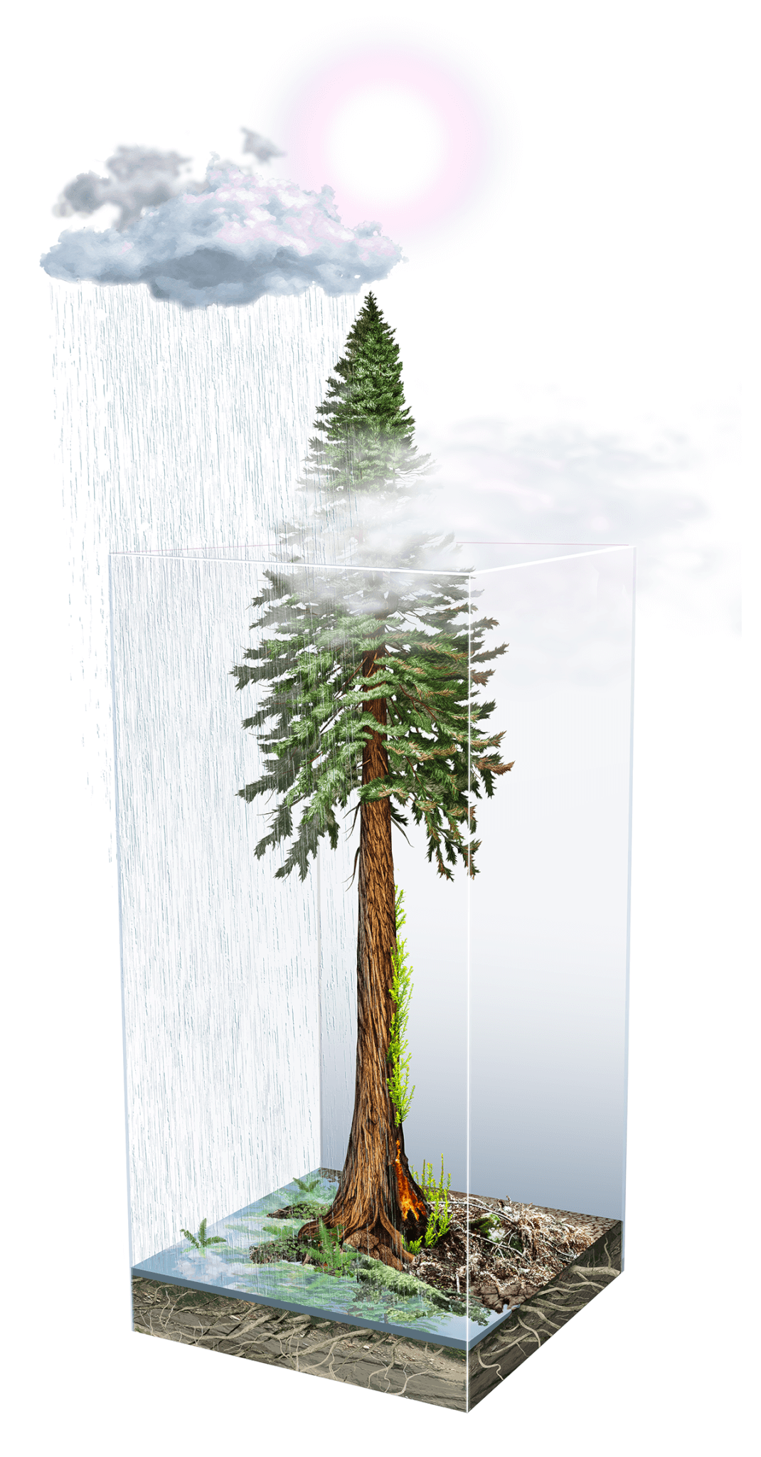
Impact of climate on redwoods by Ink Dwell studio
The Impacts of Climate on Redwoods: Part 1
Cut by deep valleys, cooled by the sea breeze, and draped in fog, the Santa Cruz mountains are a southern stronghold for California’s coast redwoods. The range’s oldest trees have withstood nearly two millennia of drought, floods, winds, fires, earthquakes, and changes made by the area’s human residents.
In the first part of this new series by Julia Busiek, Sempervirens Fund explores how Earth’s constantly changing climate shaped redwoods over millions of years, how human-caused climate change is affecting redwoods today, and what the future holds for the iconic forests of the Santa Cruz mountains.
Clues About Climate's Future from Redwoods' Past
The coast redwoods of the Santa Cruz mountains are in some ways pretty well equipped to ride out climate volatility. Each long-lived tree, and its web of relationships with other species in the forest, draws on adaptations forged over 200 million years of evolution, a timeline encompassing vast and sudden swings in temperature, precipitation, and weather patterns. Using fossils, sediment cores, and clues stored in the wood of trees both living and dead, scientists are sharpening their understanding of how California’s climate has changed in the past, and how its redwood forests have responded.
But today the climate is warming at a pace and to a degree without precedent in the last several thousand years. Is it possible to predict what the future holds for redwood forests, here in the Santa Cruz region and throughout the species’ present-day range? And how can clues from redwood forests of the past help scientists, stewards, and decision-makers understand and prepare for the changes to come?
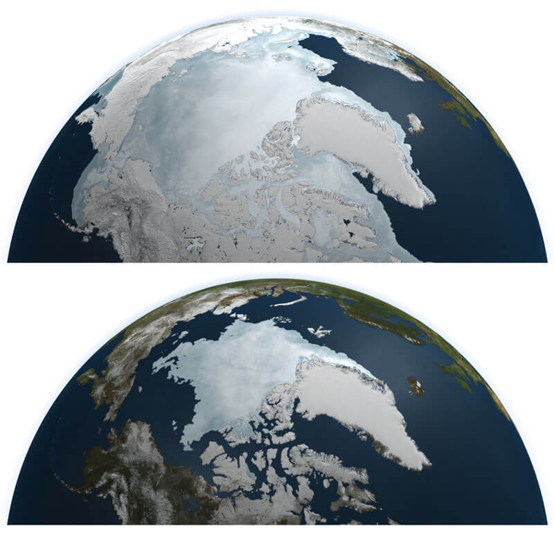
First things first—here’s just a super-quick refresher on, well, the whole history of Earth: For at least the past 3 billion years, the planet has swung between what climate scientists call icehouse conditions—when ice caps cover both poles and parts of some continents—and greenhouse conditions, during which Earth is so warm that even the poles are ice free. The swings owe to a dizzying array of semi-connected factors, including shifts in the composition of the atmosphere, tectonic plates, volcanoes, asteroids, and the amount of energy pumping out of the sun. Scientists have found evidence of five or six major icehouse eras, each lasting for tens to hundreds of millions of years.
Within an icehouse, variations in Earth’s orbit around the sun have caused shorter-term oscillations between so-called glacial periods, when ice caps expanded from the poles toward the equator and sea levels dropped, and interglacial periods, when ice caps retreated to their polar strongholds. Humans emerged and evolved during the current icehouse, known as the Quaternary, which took hold about 2.6 million years ago. The most recent glacial period—the “last ice age”—lasted from about 115,000 to 11,700 years ago. It ended with the retreat of ice sheets that once covered much of the Northern Hemisphere, and the beginning of what scientists call the Holocene Epoch, a warmer interglacial period which continues to the present.
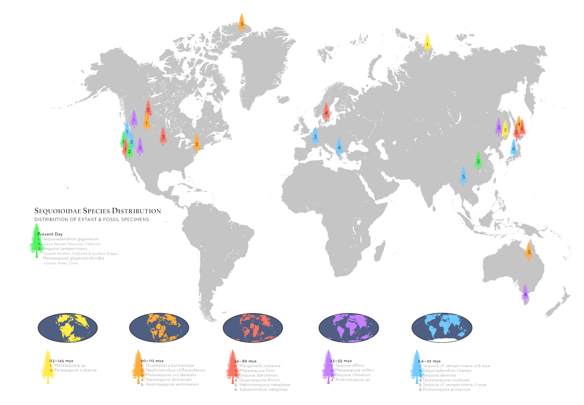
All of which is to say that the coast redwood (Sequoia sempervirens) is no stranger to climate change. The range of today’s redwood ancestors has waxed and waned, but the species’ basic physiology doesn’t seem to have changed much for tens of millions of years. Researchers have turned up fossils of Sequoia, the genus of which the coast redwood is the sole surviving member, from Texas to Pennsylvania, Colorado to Canada, and Greenland to Alaska. Fossil records suggest that Sequoia species reached their maximum distribution in North America around 30 million years ago, during a greenhouse period when the climate across the continent was warmer, more temperate, and wetter than today.
Redwoods’ longevity—as individual trees and as a species—owes in part to the fact that once they’re established in a landscape, “it’s pretty hard to kill a redwood with natural processes,” says Laura McLendon, director of land conservation for the Sempervirens Fund. They’re not particularly vulnerable to pests, their thick bark sloughs off fire, and they have the rare ability to resprout from a trunk or base if they’re burned or knocked over in a storm.
But to get growing, California’s redwoods relied on a few key conditions: “They need to have their roots wet; they can’t grow in a desert,” says Steve Sillett, Kenneth L. Fisher Chair in Redwood Forest Ecology at Cal Poly Humboldt. “And they don’t deal well with hard freezes.” As the continent’s interior dried out during the Miocene (23 million to 5 million years ago)—from a combination of global climate patterns and the rise of the Rocky Mountains—the trees’ range contracted coastward.
The rise of the Sierra Nevada, the Cascades, and the Coast Ranges in the later Miocene also shaped redwoods’ present-day distribution. The mountains catch much of the moisture rolling in from the Pacific Ocean, creating drier “rain shadows” on their eastern sides. Even on the mountains’ wetter western flanks, higher elevation regions got too cold to support redwoods. By about 120,000 years ago, redwoods grew only along the continent’s western margin, where the prevailing currents and winds from the Pacific Ocean keep the climate mild for much of the year. Today, their range peters out on the southern end in the Santa Lucia Mountains in Big Sur, about 20 miles north of Hearst Castle, and extends just north of the California-Oregon border.
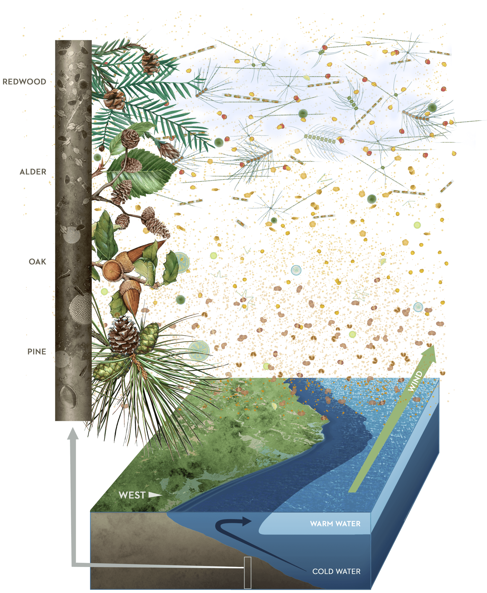
Data sources compiled by Julia Busiek and illustrated by Jane Kim, Ink Dwell studio
Each spring, pollen flushes from California’s coastal forests and is carried by streams and rivers to the ocean. Eventually the pollen settles on the seafloor, becoming part of successive layers of sediment that accumulate through time. Much as climatologists have pieced together a historical record of changes in Earth’s atmospheric composition by examining cores taken from polar ice, researchers have drilled into the seafloor off the California coast and come back with core samples containing a chronology of the region’s plant life, written in the relative abundance of pollen species in each layer of each core.
Linda Heusser, an emeritus scientist at the Lamont Doherty Earth Observatory at Columbia University, has analyzed the abundance of redwood pollen in seafloor cores to sketch out a record of climate shifts in coastal Northern California going back 500,000 years. In a 2000 article analyzing two cores taken off the coast of Northern California, Heusser identified a regular, repeating pattern: a shift over time from lots of pine, cypress, incense cedar, and western red cedar pollen to a spike in alder, followed by oak and redwood pollen, then a return to layers dominated by pine and cedar-type pollens. The researchers inferred that core sections that have more pollen from pine and cedar types were deposited during glacial periods, when the coastal climate was colder and drier, approximating the current climate in the upland and inland regions where those species grow more abundantly today.
The progression to alder, oak, and redwood forests signals an era of relative warmth and moisture, marking places where “major climatic thresholds such as glacial-interglacial transitions” kicked in, Heusser wrote in 2000. A core sample taken from the seafloor off the coast of Eureka shows variations of this successional pattern repeated five times over the past 500,000 years, transcribing five transitions from glacial to interglacial global climates.
Because redwoods require specific conditions to expand their ranges, the fluctuating abundance of redwood pollen is a fair proxy for fluctuations in coastal fog, says John Barron. He’s an emeritus paleontologist for the USGS in Menlo Park who’s studied the interactions of marine organisms, ocean temperature, and California’s maritime climate. (Barron, who’s published several papers with Heusser, is an expert in diatoms, microscopic plankton whose prevalence in the environment responds to changes in water temperatures. When diatoms die, they settle on the ocean floor along with pollen transported from land, preserving a record of the ocean’s temperature down through time.)
As a proxy for fog cover, the relative abundance of redwood pollen in sediment cores offers information about the shifts in local climate for hundreds of thousands of years. But the presence of fog on the West Coast is itself is a proxy for much bigger climate shifts, Barron explains. The fog that supports redwoods today is an effect of the California Current, a stream of cold water that flows along the coast from British Columbia to Baja California. The current powers a continuous upwelling of cold, nutrient-rich water from the deep ocean along the northern California coast, and it’s partly the temperature gradient between ocean-cooled air on the coast and hotter air inland that produces the region’s characteristic fog. But during Ice Age glaciations like the one that ended 11,700 years ago, the ice sheets covering much of the Northern Hemisphere change the Pacific Ocean’s chemistry and circulation, weakening or interrupting the California Current. “The productive upwelling we see off the California coast only happens during interglacial periods,” Barron says. “Evidence of upwelling is more or less an indicator of climate change.”
Paleoclimate records show that the planet has tended to ease into cooler glacial periods over tens of thousands of years, but the switch from glacial to interglacial conditions has typically been much more abrupt. Evidence from ice cores in Greenland suggests the planet warmed by 10°C in just 10 years at the end of the last Ice Age. (By contrast, the average annual temperature has risen by about 1°C since the start of the Industrial Revolution.) Through a chain of proxies linking redwood pollen to fog to the California Current and Ice Age oscillations, researchers studying the seafloor have sketched a map, through space and time, of how cycles of gradual glaciation and rapid warming have affected a broad swath of the West Coast, and how redwood forests have weathered these changes and survived to the present.
So, redwoods can tolerate some amount of rapid climate change. But the amount of carbon dioxide in the atmosphere has lately shot past levels unseen in over 3 million years. The atmosphere contains enough greenhouse gases that even if humans stopped emitting carbon dioxide tomorrow, the planet likely wouldn’t cycle back into the next glaciation for another 100,000 years. (Absent humans’ carbon emissions, climate scientists reckon the planet would cycle back into a colder glacial period in half that time.) But a more urgent matter for redwoods—and all the rest of life on Earth—is that we could be on track for another 5.4°C (9.7°F) of warming by 2100. What’s the outlook for the species, and for forests in the Santa Cruz mountains, in the coming decades?
In the near term, a lot may come down to how warming at a global scale affects the microclimates along the California coast, particularly the fog patterns that help moisture-loving redwoods maintain their tenuous hydrological balance through the long, rainless summer months. And the future of fog on the West Coast is a subject of lively debate and close study among climatologists and ecologists. “The effect of climate change on fog is basically a big question mark,” says McLendon with the Sempervirens Fund. An article in the Proceedings of the National Academy of Sciences noted that fog has seemed to decrease by 33% since the early 20th century. On the other hand, some researchers have hypothesized that hotter temperatures inland might supercharge the coastal winds that power the upwelling system, which could keep the redwoods cooler and foggier even as temperatures soar inland. “Whether fog stays the same, increases, or decreases will have big impacts on the survivorship of redwoods,” McLendon says.
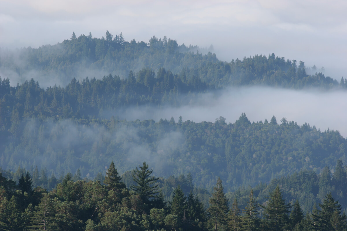
Part of what makes this question hard to answer is that the climate models issued by authorities like the Intergovernmental Panel on Climate Change are too coarse to capture the abrupt changes in temperature and moisture from coast to inland that define the redwood range. On a summer day it might be 55°F and foggy on the coast, 75°F with patchy clouds 25 miles east in San Jose, and 95°F and sunny in Livermore, 20 miles east of that. But in global climate models, “one pixel—one data point—is like 50 kilometers wide,” says Miguel Fernandez, a researcher with the German Centre for Integrative Biodiversity Research. That’s roughly the same width as the entire range of the redwoods from west to east, meaning the best global models we have basically blink and miss the whole redwood ecosystem.
In a 2015 paper in Global Change Biology, Fernandez used data from unusually hot or dry years in the past century as the basis for projections of how temperature and moisture might change within the redwood’s present range in the decades to come. His analysis zoomed way in from the scale of global climate models, splitting the redwoods’ present-day range into 800-meter pixels. Under the likeliest global climate scenarios for the middle of the century, Fernandez’s models showed that the range of suitable habitat for redwoods could contract by 50 percent at its southern end, “with no suitable bioclimate remaining south of San Francisco Bay.” But research at Big Basin Redwoods State Park published in 2020 zoomed in even further still, using recent advances in aerial imagery and computing power to capture variations in groundwater and topography on a 10-meter scale. Building on Fernandez’s findings, these researchers noted that redwoods rooted along streams in the Santa Cruz mountains might still be able to get enough water to thrive for the foreseeable future, even as trees growing further upslope dry out and die off from lack of moisture.
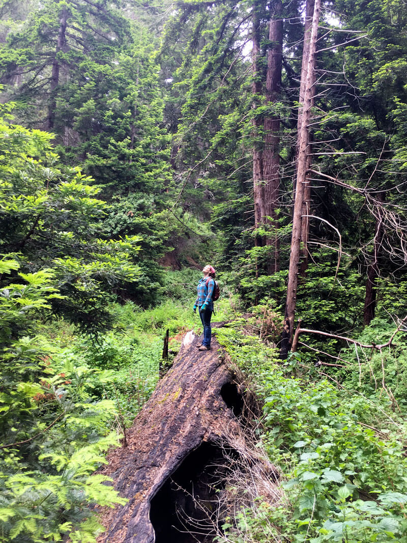
“Big Basin is the largest contiguous redwood forest that far south in the species’ range, and it’s a pretty safe bet that that forest will start to look more fragmented, with smaller, more isolated pockets of mature trees, going forward,” says Anthony Ambrose, a redwood ecologist with the forest research nonprofit the Marmot Society. The speed of that change, and its ultimate extent, will be governed partly by variables so complex that even the most sophisticated ecologists don’t dare try to predict them—namely, human behavior. “If we continue to emit carbon at the same rate that we have been, I think we’re going to see some pretty drastic changes within the next 50 to 100 years,” Ambrose says.
So, it’s a good thing that Sempervirens Fund started protecting redwoods in the Santa Cruz mountains in the early 1900s, long before scientists caught on to the consequences of industrial carbon pollution. Today we know that these forests have the potential to store more carbon per acre than almost any other ecosystem on the planet, making them increasingly valuable assets in the fight to avoid climate catastrophe. What’s more, says Laura McLendon, it’s these large, uninterrupted swaths of mature habitat that will give the species the best shot at surviving in a hotter future. “We still don’t really know what the species wants to do, or needs to do, to survive,” McLendon says.
In addition to management practices like thinning the understory and reintroducing fire to the landscape, among the best things we can do for redwoods is what Sempervirens Fund has already been doing for over a hundred years: protecting the forest and keeping it connected across the Santa Cruz Mountains. “We want different water sources, different elevations, different aspects, different slopes,” says McLendon. “It’s about integrating options to ensure we’re not missing something important that can help redwoods survive in the long term.”
More to Explore
- Read more about What Redwoods Tell Us About Climate, and Water in Part 2 of Redwoods and Climate
- Learn more about How Research Looks Deep into the Past for Clues to Climate’s Future with Jason Addison, USGS, Under the Redwoods
- Read more about how Coast Redwoods Are Our Greatest Ally in a Changing Climate
- Read our Top 10 Facts about Coast Redwoods and climb through the stories of a redwood tree
Sources
Interested in digging a little deeper into the science behind the Sequoioideae Fossil Map? Here are some of the data sources that were compiled for the map:
LePage, Ben, et al. "The Geobiology and Ecology of Metasequoia." Science and Technology Book Publications, 2005, https://www.researchgate.net/publication/37160841_The_Geobiology_and_Ecology_of_Metasequoia
Lowe, Gary D. "Geologic History of the Giant Sequoia and the Coast Redwood" North America Research Group, 2014 https://stacks.stanford.edu/file/druid:rm816zn0555/Lowe%2C%202014%2C%20Geologic%20History%20of%20the%20Giant%20Sequoia%202nd%20Printing%2C%20Revised.pdf
Stockey, Ruth A., et al. "The Fossil Record of Cupressaceae s. lat." In: Farjon, Aljos ed., A Monograph of Cupressaceae and Sciadopitys, Royal Botanic Gardens, 2005, chapter 6, https://www.researchgate.net/profile/Jiri-Kvacek/publication/273137579_The_fossil_record_of_Cupressaceae_s_lat/links/54f984e00cf2ccffe9e16a6f/The-fossil-record-of-Cupressaceae-s-lat.pdf
