San Vicente Creek: Restoring a Stronghold
photo by Ian Bornarth.
A Stream With Potential
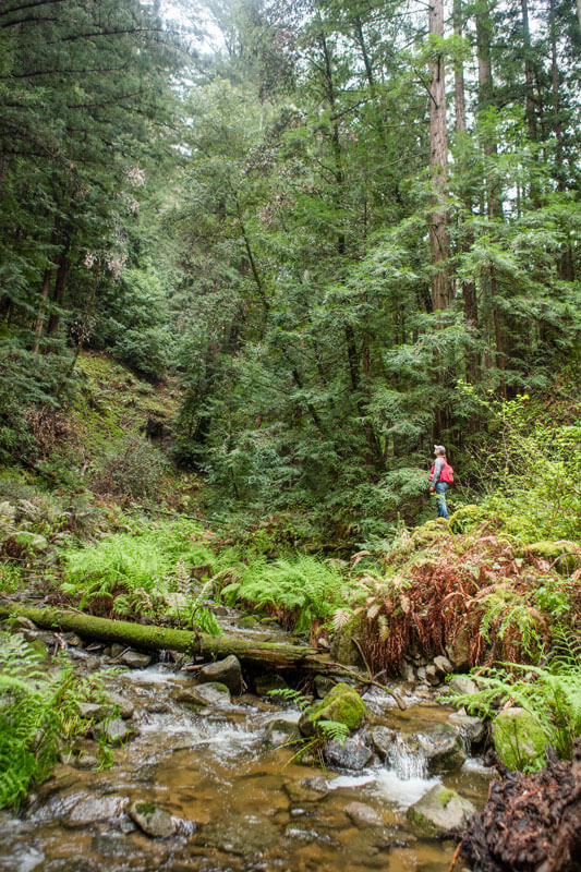
Nadia Hamey at San Vicente Redwoods. by Ian Bornarth
Towering coastal redwoods, charismatic coho salmon, and Pacific giant salamanders are, of course, main characters in this story—it’s the Santa Cruz mountains. A watershed is being restored, and in this part of the world, our eyes initially gravitate upward. But the crux of this magical restoration work along San Vicente Creek lies below us. This is a story about the granular: boulders, cobbles, pebbles, and sand.
San Vicente Redwoods is an 8,500-acre property east of Davenport. Purchased in 2014, it is jointly owned and managed by Sempervirens Fund and three partners: Peninsula Open Space Trust (POST), Save the Redwoods League, and Land Trust of Santa Cruz County. The property is protected primarily to restore, preserve, and conserve redwood forests, and watershed restoration has been a key focus at the property’s southern edge, where San Vicente Creek emerges from the trees and makes its way out to Davenport Landing to meet the Pacific Ocean.
In late September 2021, San Vicente Creek was flowing full and cold—it had the look of an early-May flow on similar small creeks elsewhere in the Santa Cruz mountains. It was surprising to a lifelong Californian, accustomed to autumns with parched hillsides and dry riverbeds. Why do I hear such a strong stream down below me?
High in the San Vicente watershed, the soil rests on a narrow band of karst, a highly porous limestone eroded and dissolved into a patch of fissures and sinkholes. These features trap and hold water, cooling it underground before releasing it in the springs that ultimately become San Vicente Creek, and further upstream, Mill Creek.
This feature is unique. Cold, persistent streams are rare here—the gift of karst. And the water is clear. In a shallow stretch across a sandbar, I had to look twice to check where the water was before stepping across the creek. The ample shade, blocking solar radiation, also keeps the canyon cool.
photo by Ian Bornarth.
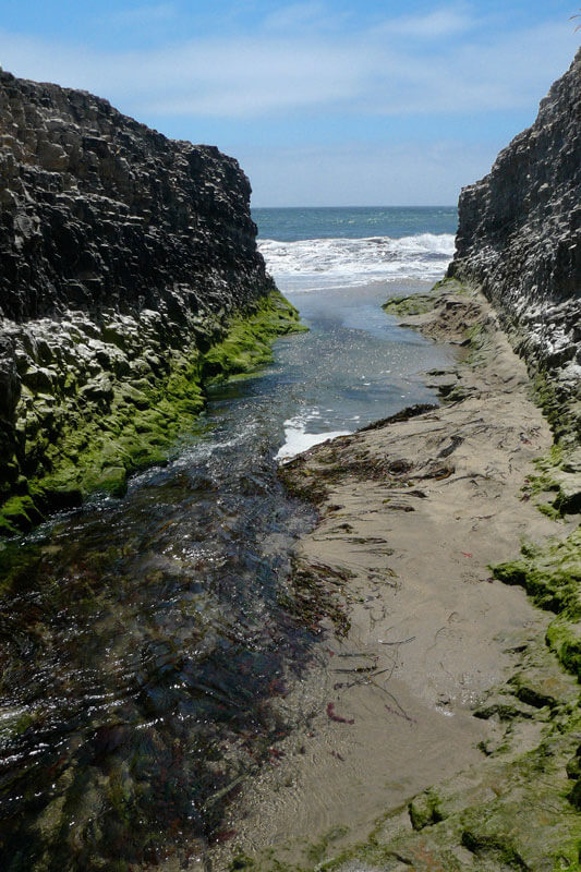
Mouth of San Vicente Creek. by Dawn Endico
Another rarity marks San Vicente Creek’s value.
Streams that host anadromous fish along the Pacific Coast typically start with an estuary. Brackish water reduces the stress of transitioning from freshwater to salty or back again. Side channels offer cover from predators and rich sources of nutrients for young smolts heading out to sea. In the Santa Cruz mountains, just north of Davenport, the estuary at Scott Creek is gorgeous, easy to spot from the highway, and appears to be teeming with possibilities.
But San Vicente Creek no longer has an estuary. For the last 200 yards of its run to the sea, it flows through tunnels, a bore through bedrock under the railroad and a box culvert under Highway 1. Though an uninviting doorway, this holds an important advantage. Because it doesn’t meander, instead passing in a straight shot to the ocean, it is less likely to lose energy and be stopped by a sand bar. (This is the case with several local creeks—they don’t flow fully to sea in low-water years.) At San Vicente Creek, even in low-flow years, the entry is there—migrating steelhead and coho can find their way home to spawn. Looking ahead to a greater likelihood of sustained drought, this may turn out to be a real benefit.
The National Marine Fisheries Service (NMFS) and other federal, state, and local agencies saw these characteristics and concluded that San Vicente Creek had the best shot of being a viable home for steelhead and coho salmon at the southernmost end of their range. The creek is also home to other species of concern, including marbled murrelets and California red-legged frogs.
Human Impacts Along the Creek
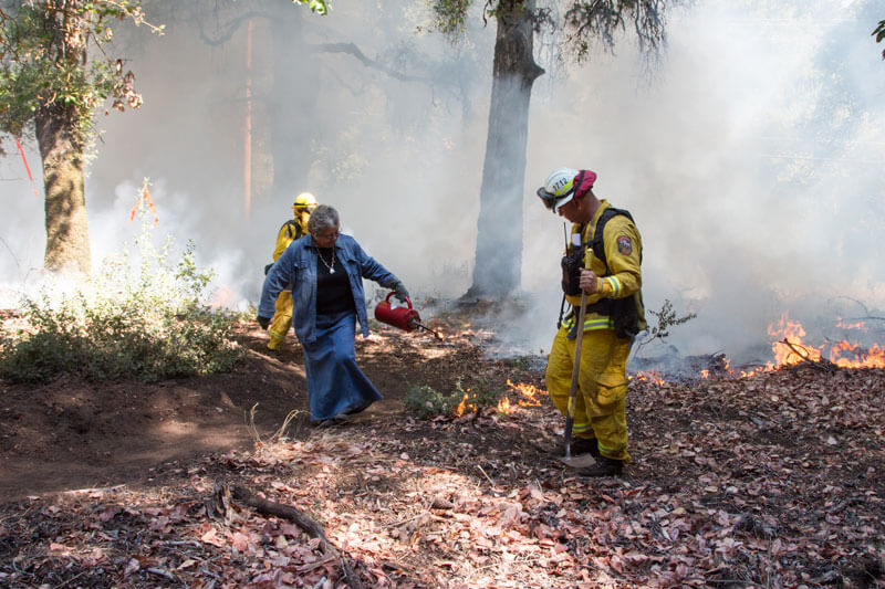
Prescribed burn at San Vicente Redwoods with AMLT and Cal Fire.
San Vicente Creek wasn’t quite ready to be a stronghold for these species, however. The stream had potential—and problems.
Redwood trees have built-in protection for a reason: fire has always been a part of their ecosystem. Fire cleared understory, allowed for stands of different ages, and left remnants of trees as harbor and sustenance for fauna of all kinds. For eons, fires were started by lightning; over time, some fires were set consciously. Indigenous Peoples used fire to keep the land open so they could spot both predators and prey, hold back adverse pathogens, and propagate plants for food, medicine, and crafting. This was before fires had names, like the Pine Mountain Fire in 1948, the Lockheed Fire in 2009, and the CZU Lightning Complex in 2020.
But Indigenous communities were forced from these lands. Their long-practiced techniques for stewarding land, water, and life were dismissed. And since the Gold Rush, logging and more intense fires have altered the system. Nearly all redwoods in the San Vicente watershed are of the same generation. With such even competition, few will reach maximum height. And a forest of even-aged trees is risky for generational succession.
photo by Jason Jaacks.
Invasive plants—in this case, houseplants brought from other global regions—took root in the lower reaches of the watershed. Cape ivy and clematis are climbing vines that cover and overwhelm native plants, depriving them of sunlight and the ability to photosynthesize. Cape ivy spreads by rhizomes; clematis is more rampant, spreading both by rhizomes and by seeds that are often set airborne once the vines have reached the crown of a tree. Spreading unchecked, clematis took its toll on dozens of acres of redwood forests in the watershed.
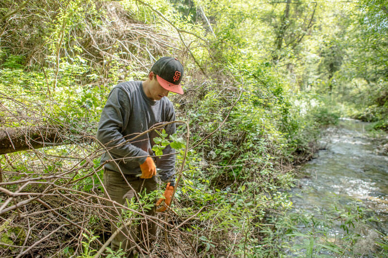
Ian Rowbotham removing invasive plants. by Ian Bornarth
Sempervirens Fund and its partners are in the third and final year of a clematis removal program along the creeks. The team has been trying different methods of clematis eradication, is documenting its approaches, and will continue to monitor progress. But in September, at the confluence of Mill and San Vicente creeks, I saw standing remnants of maple and willow, smothered and still covered by now-dead clematis vines. And beneath those trees, a wide range of smaller native plants had been killed. The impacts are cascading—these plants shelter and feed all kinds of wildlife, up and down the food chain. Clearing out the remaining clematis can’t come soon enough.
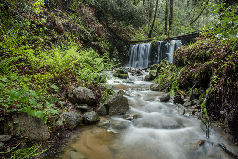
And San Vicente Creek was changed utterly when the dam was built on Mill Creek. The dam trapped the boulders, cobblestones, woody debris, and other material that had previously been carried downstream. Without the boulders and other large objects to divert flow, there was nothing to slow the creek’s water. Fast winter and spring waters cut deeper into the creek; waters no longer spilled over onto the floodplain, because the flow, even in winter, was well below that plain. When the river bottom was cut down to bedrock, there was no way deep pools would develop, depriving large fish of essential safe harbor. What should have been a winding stream had become a raceway.
Long Before Dam Removal
Mill Creek dam before removal. by Ian Bornarth
Since the purchase of San Vicente Redwoods, Sempervirens Fund and its partners have seen restoration of the creek as central to its work there. Getting the stream back to health was important to watershed health and to the health of species that range thousands of nautical miles.
The dam would need to come out. But not right away.
Removing the dam and letting loose the materials behind it was an essential step. But unless there was a way to capture some of those materials and hold them in place in the creek bed, the material would be wasted. Rather than staying in the creek bed, it would simply flow through it. And if the conditions weren’t right for the restoration of native plants along the creek’s floodplain, the opportunity for restoration would be squandered.
The team created or installed 13 large wooden structures that essentially acted as intentional large woody debris at intervals on San Vicente Creek. Put in place in 2018, most of these structures are made of two or three redwood trunks or large canopy branches crossing the full creek and wedged in against rocks, tree stumps, or other stable objects. The material for them came from cutting 40 small redwoods into large sections. (This helps meet another recovery goal: thinning a ring of even-aged redwoods puts individual trees in better position to reach full height, fill out the forest canopy, and cultivate new generations of healthy growth.)
"Each time we visit we understand more deeply how connected everything is in this watershed. By setting up these large woody debris structures in the creeks to slow flow and capture migrating sediment and smaller debris, we hoped to improve marine conditions. But of course they also became bridges for wildlife too. Plant life is making its way across the stream. This place is amazing."
- Ian Rowbotham, Land Stewardship Manager, Sempervirens Fund
Even before the dam came out, these introduced structures were changing the creek dynamic, creating pools, and improving habitat for fish and other species. A small gravel bar appeared at the confluence of Mill and San Vicente creeks—between two of the large woody structures, as the team had hoped. Two massive steelhead had taken up residence there late in the spring and were spotted occasionally through the summer. In August, Ian Rowbotham, Sempervirens Fund’s Land Stewardship Manager, was checking in on the structures and found himself hopscotching pools with a great blue heron. As Ian studied one pool, the heron alighted on the next. When Ian moved upstream, so did the heron. They both knew where the aquatic wildlife was most likely to be.
Then there was the issue of coaxing native plants to flourish once the stream was reconnected with its floodplain. The clematis removal project offers a reminder of another advantage in this watershed. Land ownership had not been carved up. There are only two owned parcels along the creek: San Vicente Redwoods and the Cotoni-Coast Dairies National Monument, owned by the federal Bureau of Land Management (BLM). This has made planning and access relatively easy—unlike removal of the plants!
A Restored Stronghold
The actual removal of Mill Creek’s dam had the feel of an overnight sensation that in fact comes after a decade of work. The dam was removed quickly, most of it in the course of a single day. It was, of course, a day that followed years of preparation and staging. The planning process was inclusive, thoughtful, and comprehensive, and the long list of precursor actions was checked off deliberately. And then the dam was gone.
Here, we return to the granular details. Behind the dam was a trove of the materials required for a healthy riverbed—such stuff as streams are made of.
Boulders and cobblestone sequestered for a century behind the dam will, with heavy rains, descend Mill Creek and flow into San Vicente Creek. They will wedge against banks, against roots, against each other. They will push up against the large wood structures so carefully placed. Again stuck in place—this time the right place—they will resist flow, shifting the creek’s direction, if only briefly. Natural dams will form, and the creek may start to resemble a beaver colony’s reach, with water now slower and deeper.
photo by Ian Bornarth.
The gravel and sand from behind the dam will find their more natural angle of repose. With the boulders, cobbles, and woody materials in place, these lighter granules will no longer race through the stream but will be part of it. The slowed water will allow the material to settle, raising the river bottom. Sand bars and gravel beds will form. As the bed continues to rise, high flows will spill over the banks, reconnecting stream and floodplain. The water will find alternate paths of descent as side channels open and braid across one another.
The gravel is right for the spot. Steelhead and coho both make spawning beds using gravel one-half inch to six inches in diameter. Because most of this watershed is underlain by quartz diorite, a dense igneous rock similar to granite, the gravel resists breaking down into smaller pieces. In the days after the dam removal, long before the mass of material would be moved down the canyon, I saw the transport of this specific gravel quite clearly. In a shallow pool just below the dam site, the bottom was covered by coarse, spotted stones roughly two inches across.
There were other materials behind the dam as well that will be put to use again. Dozens of native plants were taken from atop the heap behind the dam and were replanted at the confluence of Mill and San Vicente creeks. Thimbleberry, rush, sorrel, and ferns—chain, bracken, lady, and western sword—will fill in for the plants once smothered by clematis.
It’s all in place.
Step By Step
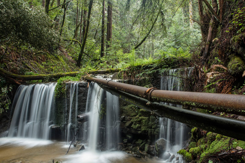
Water pipes across the Mill Creek dam. by Ian Bornarth
The sequence mattered. Purchase the land to prevent subdivision and development. Inventory and monitor the natural and the invasive species. Chronicle evidence of management practices developed by Indigenous Peoples in the region. Engage in planning processes that involve more than a dozen partners. Ensure that the stream is ready to sort and capture sediment from dam removal. Prep the floodplain for botanical restoration in the wake of clematis removal.
All that work to get ready had been done—a deliberate course—but the timing still wasn’t right. For decades, a heavy plastic pipe connected Davenport with a backup water supply further up Mill Creek. The line ran across the dam and rested on the solid mass that collected behind it. The concrete company, CEMEX, still owns the creek’s water rights and water infrastructure, and the placement of that line gave the company pause when considering dam removal.
In August 2020, the CZU Lightning Complex reared up—a horrifying conflagration with frightful consequences. And while the wildfire had slowed to a crawl and most of Mill Creek watershed had been spared, the fire destroyed the water line resting atop the dam. A new line was to be installed, this time without relying on the dam. This was the final obstacle. Terrible though it was, the moment had arrived.
photo by Ian Bornarth.

"Sometimes a grand vision becomes a reality, and that’s the case here. But that only happens with dedicated and smart partners having the patience and tenacity to collaborate over many years to protect contiguous properties stretching from coast to crest, then together stewarding and restoring their natural and cultural resources for wildlife and people."
- Julie Turrini, Director, Resources Legacy Fund
Thirteen months after the fire, and ten years after purchase of the property, the dam was gone.
Even the ten-year timeline within San Vicente Redwoods understates the extent of the planning involved. The parcel starts roughly two miles from the coast, and those are important miles for coho smolts heading out to sea or mature fish returning to spawn. This is where the methodical approach to restoration really began.
For generations, a small group of families ran dairy operations along the coast north of Santa Cruz. But in the mid-1990s, a Las Vegas developer purchased development options and planned to build 150 luxury homes on what was known as the Coast Dairies property. With funding from the David and Lucille Packard Foundation, the 7,000-acre property was purchased by The Trust for Public Land for conservation purposes. This single step helped protect six distinct watersheds that held anadromous fish. The purchase stopped development but also initiated a long-term restoration process, with support and guidance from Resources Legacy Fund.
Coastal sections of Coast Dairies were turned over to California State Parks, and the bulk of the land was transferred to the BLM—but only after detailed planning processes provided clear direction for how the land should be managed. Sempervirens Fund and others helped build the public pressure that led to even greater protections with the 2016 designation of these new federal lands as the Cotoni-Coast Dairies National Monument. There is no settling at this point—Sempervirens Fund is actively engaged with BLM to ensure a thoughtful resource management plan is in place.
A twenty-five-year timeline—at least—is what it has taken to build in protection for San Vicente Creek, from the coast to the crest. Nothing was rushed. Everything was done in a conscious order. And, as is always the case in nature, nothing is ever really finished. But the magical process of restoration has been unleashed. It will have been worth the wait.
photo by Ian Bornarth.
More to Explore
- Read more about the Mill Creek Dam and the San Vicente Watershed
- Read more about protecting and restoring San Vicente Redwoods
- Read more about Protecting Wildlife in the Santa Cruz mountains